The Topography
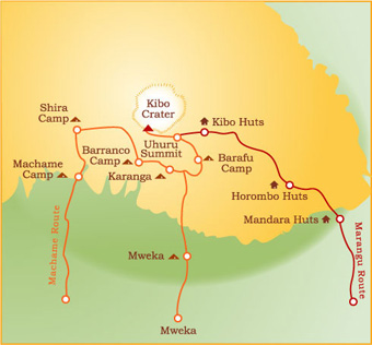
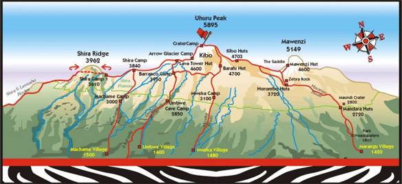
Kilimanjaro rises from plains at approximately 2000 meters, right up to 5 895 meters. An ancient volcano, it now lies dormant except for some tell tale signs of fumaroles in the ash pit. Two other peaks, namely Mawenzi and Shira, flank the main peak of Kibo. These peaks form spectacular photographic backdrops when viewed from various vantage points along the routes to the summit.
The different routes to the summit pass through five ecological zones, being the cultivated lower slopes, Montane forest, heath and moorland, alpine desert and the ice capped summit.
The lower slopes of the mountain are mainly used for agricultural purposes.
The climate here is ideal for the production of coffee, an industry that Tanzania is famous for. Further up, a rain forest belt encircles the mountain up to about 2 00 meters. As you proceed higher, you pass through the heath which changes into moorland, semi-desert at altitude, progressing into total desert and finally into an alpine region with permanent ice glaciers. The higher slopes are covered with scree, loose stones resembling gravel, making it more difficult to negotiate. The main glaciers edging their way down the slopes of Kibo are Heim, Rebmann, Decken, Arrow and some smaller ones. These glaciers form the permanent ice cap of the mountain, although they are, as a result of global warming, believed to receding each year.
The Climate
Being only 3 degrees south of the equator, Kilimanjaro is influenced by the passage of the Inter-tropical Convergence Zone. There is a constant feeling of summer, and there are two rainy seasons to keep in mind. The highest rainfall occurs from March lasting until about the end of May. This is monsoon time. Slightly less rain falls during the short rainy period, which occurs from around October to November, but can extend into December. Apart from these factors, climbing Kilimanjaro remains fairly constant throughout the year.
The maximum rainfall occurs in the forest belt, where it can reach up to 2000 mm per year. At the summit, which can be, describe as a “high altitude desert”, the rainfall reaches less than 100 mm per year. Rain (and snow at higher altitudes) can however be encountered at any time of the year.
The average temperatures at the foot of the mountain is 25°-30° C and on the summit, it can range from minus 10° -20° C. At 3000m the day temperatures range from 5°-15° C, and at night frost is normally encountered. Clearly a large variation, making it more interesting to summit the mountain.
How difficult is the climb-can I do it
About 22,000 climbers set out every year to conquer the Kilimanjaro peak. Several well-marked hiking routes lead to the summit of the mountain. To use the word “climber” is not always correct. Although none of these hikers routes really requires mountaineering skills, hiking to the “roof of Africa” is physically and mentally demanding and should not be under estimated. As much as 40% of those who set out to climb Kilimanjaro turn back before they reach Uhuru peak.
Today, hikers make up the bulk of all those who conquer Kilimanjaro, and the mountain is in fact one of the highest peaks accessible to hikers in the world. Of course there are extremely severe climbs available, including some grade 3+ climbs, but those we leave to the professional alpine climbers and experienced mountaineers. The information on this website is primarily concerned with the hiking routes, which “the average hikers” can follow successfully.
With the adequate preparation any reasonably fit person above the age of 12 years can reach the summit successfully, in fact the oldest person to date to reach the summit was a Frenchman Valtee Daniel at an age of 87!!
Preparation both physically and mentally is the keywords for success– this web site contains valuable and comprehensive information obtained from 9 years of experience and through the feedback from more than 4300 clients. We believe it will positively contribute to your chances of successfully conquering Kilimanjaro.


